


Road Closures
To facilitate the safe passage of participants, it will be necessary to implement road closures along the route, which have been agreed with Bridgend County Borough Council. Please note that we work closely with the emergency services, whose access to the route will not be affected by the event.
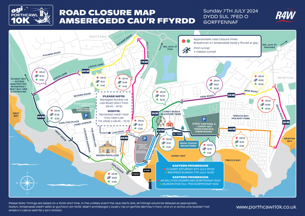
You can view or download a copy of the road closure map (with precise road closure timings) below – this will also explain when to expect the first runners around the route – to help you plan alternative parking or travel arrangements.
The route has been designed to keep disruption to residents and businesses to a minimum. There will be diversions to routes serviced by the X2, 63 and Stagecoach 172 buses, please check www.firstgroup.com/south-west-wales and www.stagecoachbus.com before travelling.
The route will start and finish outside the landmark Grand Pavilion. It will showcase the very best of the town taking in Newton & Bay, Coney Beach Fairground, Trecco Bay Holiday Park, John Street and Locks Lane before finishing on the seafront and Esplanade.
We apologise in advance for any inconvenience this may cause and assure you that we will keep any disruption to a minimum. We wish to thank you for your understanding and we are grateful for your support and cooperation.
If you are not taking part, we encourage you to turn out on the day to join the thousands of spectators who will be cheering on the runners, or why not get involved and support by volunteering!
View or download a copy of the road closure map below, including colour coded sections with corresponding closure times. Use our interactive Google Map if you’d like to inspect the route in more detail.
If you have any queries you can contact us here.